
Export data
ORBAT Mapper can export units and features to these data formats:
Start the export
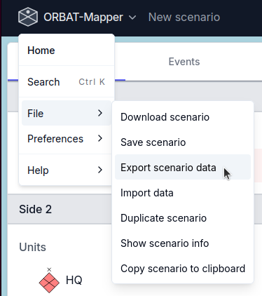
To start the export, select Export scenario from the File menu.
GeoJSON
GeoJSON is an open standard format that many applications use. It gives simple geographical features with their non-spatial attributes.
KML
KML (Keyhole Markup Language) is a format that uses XML. Mapping applications such as Google Earth use it to show geographic data. When you export to KML, you can easily send your scenario data to usual geospatial tools and show it there. For more data, see the KML documentation.
Control measures are exported as their complete rendered geometry with resolved line, fill, opacity, width, and label styling. KML has no portable dash-pattern or patterned-fill primitive, so those paint details use a solid fallback in KML/KMZ viewers.
KMZ export offers two control-measure label modes. Native keeps labels searchable and compact, but KML viewers draw them upright. Rendered embeds labels and text amplifiers as transparent images so their orientation, pixel size, anchor, typography, background, and halo are retained. Plain KML always uses native labels because it cannot package the required image assets.
XLSX
Export units to the Microsoft Excel format (.xlsx). Use this format to send unit data to spreadsheet applications, or to do more analysis.
Export options
- One sheet per side: If you enable this option, the export makes one worksheet for each side in the scenario. If you disable it, the export puts all the units in one sheet.
Unit attributes
Select the unit attributes for the export:
| Attribute | Description |
|---|---|
| id | Unique unit identifier |
| name | Unit name |
| sidc | Symbol Identification Code (SIDC) |
| shortName | Abbreviated unit name |
| description | Unit description |
| url | External URL |
| location | Current position of the unit |
| parent ID | ID of the parent unit |
| side ID | ID of the side of the unit |
| side name | Name of the side |
Location format
Select the format of the coordinates in the export:
| Format | Example |
|---|---|
| JSON array [lon, lat] | [10.7522, 59.9139] |
| Lat, Lon | 59.9139, 10.7522 |
| Lon, Lat | 10.7522, 59.9139 |
| MGRS | 32VNM8546314523 |
| Degrees Minutes Seconds | 59°54'50"N 10°45'8"E |
| Decimal Degrees | N59.9139° E10.7522° |
MilX
ORBAT Mapper has experimental support for the export of a scenario as MilX layers. You can use these layers with map.army.
WARNING
ORBAT Mapper supports only a small part of the MilX format. There is also an important compatibility problem. Map.army uses MILSTD 2525C/APP6-C symbol codes with letters. It is not always possible to change 2525D/APP6-D codes into 2525C/APP6-C codes. ORBAT Mapper tries to find the symbol that agrees most closely, but this operation can fail.